

Introduction
The preceding lessons provide a background in the fundamentals of rating curve concepts and several ancillary topics. A portion of the material in the previous 9 lessons provides background knowledge that can assist hydrologists in making operational as well as developmental decisions, and a portion of the material directly relates to daily NWS hydrologist operational activities.
The purpose of this lesson is twofold. The first objective is to revisit some of the high points of the lessons and summarize how they are relevant to operational river forecasting. Secondly, the lesson addresses the situation when flood levels exceed the limits of official rating curves. The material revisited here was selected to serve as an example for how the material presented in the other 9 lessons can be either directly or indirectly folded into operational procedures.
Two approaches will be used to cover the material presented in this lesson. First, a lesson-by-lesson recap will be used for some of the first 6 lessons. This review will be followed by a discussion of operational procedures based on a hypothetical rating curve.
Terminology Review
Several terms presented in earlier lessons are used repeatedly in this lesson and redefined here to facilitate understanding of the material presented in this lesson.
- Rating Curve: The line used to fit stage-discharge measurements, or the plot of a rating table. These can be slightly different and the context of use should clarify which definition is intended.
- Rating Table: The stage-discharge relationship as extracted from a rating curve and adjusted by any documented shifts.
- Stage-discharge relationship: The underlying transformation between stage and discharge. The transformation can be expressed in a number of ways including a rating curve, and equation (such as for a weir), and a shift adjusted rating table.
- Rating: Can refer to any of the above.
Selected Operational Issues of Previous Lesson Topics for NWS Hydrologist
Lesson 3: Selection of a Gaging Station
Selection of a gaging station location is rarely based on the requirements of operational river forecasting. Generally, access, safety, and the quality of the controls are determining factors. As a consequence, the river gage site - which determines the river forecast point location - may not be the most advantageous for river forecasting. For example, a confined channel cross section provides the best high flow channel control, compared to a wide flood plain cross section. Impacts, however, frequently exist in the wide flood plain areas. It is the purpose of the E-19 reports to correlate impacts in one part of a flood reach to stages at the forecast point. Operationally, it should be remembered that in instances where the forecast point is in a confined section of the reach, and the impacts are in a wide part of the reach, these correlations are more tenuous, E-19 data more critical, and flooding that exceeds previous records carries with it more uncertainties regarding impacts. There is also more potential for confusion on the part of NWS customers. For example, if a previous 10 feet of stage at a forecast point within a confined channel produced minor basement flooding of a residence located in a downstream flood plain, the homeowner could erroneously conclude that 20 feet of stage at the forecast point would result in the first floor of the home being completely under water. Flood inundation mapping in real-time will mitigate these problems for some high population areas.
Lesson 4: Stage Measurement
This lesson addressed stage measurement from the perspective of (1) developing stage-discharge relationships and streamflow data, and (2) real-time monitoring of stream data. The former was intended to give the reader a behind-scene appreciation for what goes into developing these critical components of river gaging, from both an equipment and procedural perspective. The insights into real-time monitoring of stream data followed from the main theme of the lesson. This insight can enable the operational hydrologist to detect and identify problems with critical streamflow data and take corrective or mitigative measures to maintain operational effectiveness.
Lesson 6: Simple Stage-Discharge Curves
This lesson ties together much of the material of the previous lessons and provides an overview of the procedures used to develop actual rating curves and rating tables that define the stage-discharge relationship for a gaging station. In doing so, this lesson reveals to the operational hydrologist the nuances, subjectivity, and strengths and weaknesses associated with the development of a stage-discharge relationship. Without this insight, the operational hydrologist can use stage-discharge relationships blindly even though they facilitate one of the most critical transformations in the river forecasting process.
This lesson also demonstrates how to read rating curves and rating tables to glean information that is valuable during operational situations. This allows the operational hydrologist to see a rating curve or rating table the same way a river gaging hydrologist sees them: as a window into the structure and behavior of the river. For example, it was shown how the characteristics of a rating curve can be used in real-time to assess the rate of rise behavior of a particular reach of river, and to identify the stage at which a rate of rise behavior will change.
Interpreting rating tables is also important from an operational standpoint. For example, the three data pairs used to characterize a shift can be interpreted to convey the level of uncertainty associated with a particular stage-discharge relationship. When the input values indicate that a developing shift is affecting the high flow portion of a rating, and the high end of the shift has a shift value greater than zero, the shift is not fully defined because of a lack of high flow measurements. Noting this in a rating table can tell the operational hydrologist that the uncertainty associated with the rating is higher than normal for flows above the level for which the shift has been documented.
Lesson 7 and the Complete Rating Curve
Figure 10.1 serves as a useful reference for the material of Lesson 7 and later lessons. The lesson also facilitates discussion regarding the situation when a flood exceeds the limit of an official rating curve. Figure 10.1 shows a hypothetical stage-discharge relationship that is applicable from low flow to beyond the official rating. Four sections are color coded to facilitate directed discussion of the issues pertinent to the respective sections of the stage-discharge relationship.
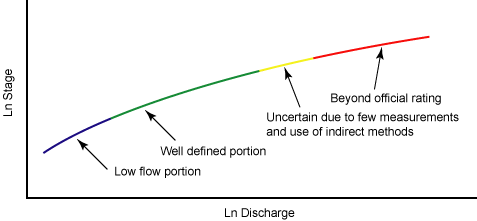 |
| Figure 10.1. Typical rating curve. |
Low flow portion (blue color)
This portion of the rating curve impacts river forecasting during low flow conditions. It is not critical that operational hydrologists prepare to make operational decisions based on an understanding of the low flow portion of a rating curve because low flow conditions are not time critical. They afford the time to make decision in consultation with the agencies that maintain the stream gage station.
Well defined portion (green color)
This is the portion of the rating curve for which adequate good quality measurements are available to define the stage-discharge relationship. Recall from Lesson 6 that many good flow measurements are required to initially define a rating curve and then frequent measurements are needed to verify that the curve is still valid (for most natural streams).
The major source of uncertainty associated with this portion of the rating curve can occur during the life of an event. Channels can scour and fill (sometimes repeatedly) during large events. The uncertainty that results cannot be quantified or even estimated by performing background work. The most that can be done is to note that a particular reach of a river is prone to this behavior.
Other than the above issue, the stage-discharge transformation process should be considered reliable for events that fall within a well defined portion of a rating curve. The errors that may exist in this portion of the rating are not likely to be significant for operational river forecasting. In fact, the accuracy of this portion of the stage- discharge relationship provides its own unique operational challenge. Many floods fall within this portion of the rating, such as floods with 1 to 2 year recurrence intervals. Since the rating is well defined, the results from the rating are accurate for these frequent floods. This can build a false sense of confidence in the use of stage-discharge relationships that may not be appropriate for very high flows that fall on the very end of a rating.
Uncertain portion (yellow color)
The transition from the green to the red portion of the rating curve in Figure 10.1 represents the point at which the uncertainty becomes greater than for the lower portion of the curve. This characterization of the transition as a distinct point is only used for illustration purposes. In reality, this point is very difficult to firmly establish for several reasons. First, it involves an unquantifiable gradual increase in uncertainty. Secondly it differs for each site. And thirdy, it can change dramatically over time for the same site. Even with these problems, some guidelines can provide a useful way to qualitatively assess the level of uncertainty associated with a portion of a rating curve
There are two basic sources of uncertainty that are unique to the high end of a rating curve (real-time scour and deposition, as discussed in relation to the well defined portion of the rating curve also applies to the high end). These concepts were discussed in Lesson 7 and are revisited here from the standpoint of the background work needed to ensure operational readiness.
The first source of uncertainty is related to the number of, and quality of, high flow measurements. Fewer high flow measurements are possible because there are less high flow events. Furthermore, for extremely high events, indirect flow estimation methods are used because of access or safety reasons.
The best way to determine the event size above which these two factors become significant is to talk with the agency responsible for maintaining the gaging station and rating curve. When talking to the staff that actually maintain a gaging station, make it clear that you are inquiring about shifts, channel changes, and uncertainty associated with high flow. They spend a significant portion of their time addressing low flow shifts that occur continuously in many natural channels. These impact low flow measurement and are important to many water resources disciplines, including the NWS drought program. They usually have little impact, however, on the high end of the rating that operational hydrologists are concerned with during flood events.
The operational hydrologist should review critical sites with the maintaining agency staff and make notes regarding the event size above which they feel the uncertainty begins to increase due to inadequate measurements and any other reasons. They should specifically note the highest event size that was directly measured, and the highest event ever measured. The portion of the rating above the highest directly measured event is more uncertain because of the uncertainty associated with these methods. The portion above the highest event ever measured is more uncertain because it has been extended. Unfortunately, it is not always possible to assess the number or quality of measurements used to develop the various portions of a rating curve. In this case, a rough estimate can be made based on the record of annual peak flows. After the peak events are ranked, they can be compared to the rating curve to determine where in the rating the measurements become scarce, and where the rating is extended above the highest event on record.
The second reason why the high end of a rating curve can be more uncertain is related to changes to the river system over time. Because high flow events occur rarely, significant changes can occur to the stage-discharge relationship that go undetected. Examples include human activities in the high flow portion of the channel, or flood plain, such as logging and urban development. The lack of high flow can also directly affect the channel by allowing the growth of trees in the portions of the channel and flood plain not inundated. The river system changes illustrated in these examples can dramatically change the roughness coefficient of the channel and therefore impact the depth of a given flow. If these changes occur over a period of time for which no high flow occurs, their impact on the stage-discharge relationship will not be reflected in the rating curve. The next high flow that does reach into the changed channel areas will result in a stage that is different than that predicted by the rating curve. Because of backwater effects, this effect can occur at a gaging site that is far removed from the area that is undergoing change. In other words, both the stage-discharge relation and the stage-impact relation (E-19) can be impacted by changes in the river, and those causative changes can be distant from the gage and flood impacts. These undetected changes are less likely for lower flows because more frequent measurements are possible and these are used to document the change. Note that the above river system changes are long term chronic changes that are different than the acute scour and deposition that can occur during a single high flow event. Both chronic and acute changes can impact the accuracy of a rating for any given event.
Operational hydrologists can qualitatively monitor the occurrence and significance of channel changes that are not reflected in the rating curve by considering the streamflow record and their local knowledge of the river through time. The goal is to look for significant changes to a river reach that have occurred during a period of time that also happens to be relatively free of high flows. Periods of documented drought are good candidates but even periods of normal average flow can yield few large events. For example, consider a river system that has had 9 years of below normal flow conditions with no high flow events above the 2 year recurrence interval. Under these conditions, no events over the 9 year period have reached significantly above the active channel, and therefore no measurements have been possible to document changes in the rating curve. In addition, the riparian and active channel vegetation would have grown significantly because there have not been adequate events to knock down the growth. Assume that during the same 9 year time, much of the flood plain has been converted from irrigated crops to vineyards and tree farms, and a good portion of the flood plain has experienced urbanization. This occurrence of events should raise a red flag that the high flow portion of a rating for a gage site upstream of this area will likely underpredict stage for a forecasted large flow.
The monitoring of river states over time should be done periodically by WFO hydrologists and the findings forwarded to their supporting RFC. Providing this type of local insight into conditions that can affect river forecasts is a major benefit of having hydrologists at NWS field offices.
If there are adequate measurements to document the lower portion of a change in the stage-discharge relationship, and the change appears to be semi-permanent, then it may be reflected in a documented shift that is not fully defined. This situation was covered in depth in Lesson 7, including how to identify this situation by examining the characterization of the shift. If the shift occurs high on the rating, as indicated by the input values, and the shift does not trend to zero, as indicated by the final shift value, then the shift properties are not known for higher flow. WFO and RFC hydrologist can easily determine if any of these shifts are in effect by looking at the official published rating, and should do so periodically.
Finally, a specific river process should be mentioned that can result in undetected, partially defined, or fully defined shifts in a rating. For some rivers, scour and deposition events can be episodic over decades as pulses of sediment move through the river system. These pulses of sediment can be released into a river system from such events as large earthquakes, extensive forest fires, or anthropogenic causes. As they move past a gaging site, the channel will first fill and result in a shift in the rating. The staff that maintain gaging stations generally have identified the cycle and can provide insight into the future behavior a rating curve can be expected to exhibit based on previous trends. In association with WFO hydrologists, this information can be communicated to RFC hydrologists.
Beyond official rating (red color)
The last part of the rating curve in Figure 10.1 is labeled "beyond official rating". This portion of the stage-discharge relationship is not described by the official rating curve (there would be no curve for these combinations of stage and discharge). Typically, official rating curves are based on direct or indirect measurements of real flow events and therefore, by definition, do not extend significantly beyond the flood of record.
The flood of record is not a reasonable upper limit beyond which NWS river forecasting methods begin to break down. Each flood of record becomes such by exceeding the previous flood of record, and will some day, in turn, be exceeded by a new flood of record. NWS methods, therefore, should continue to function well beyond the "current" flood of record. This has been recognized by the NWS and USGS, and efforts are underway to extend rating curves to the 200 year recurrence level at critical sites. Hydrologic and hydraulic analysis methods of varying degree of complexity will be employed by the USGS to accomplish this goal. Such analysis is beyond the scope of this training module, but it is appropriate to: (1) cover the basic concepts associated with such an endeavor, and (2) outline some simple and parasitic methods that can be used by operational hydrologists with a minimum of analysis and technical expertise. At the very least, such a treatment will enable the operational hydrologist to be an informed user of rating curves extended by other agencies. It can also assist the operational hydrologist develop local qualitative methods for sites that are not extended by other agencies.
Extending Rating Curves
The simplest way for an operational hydrologist with the NWS to extend a rating curve is to do nothing. The NWS River Forecast System automatically performs a logarithmic extrapolation to extend the official rating curve if the flow exceeds the rating limit. Recall from Lesson 6 that the log function does a fairly good job of correlating stage and discharge for natural channels. This automatic extrapolation is not a bad first estimate in many cases. There can be, however, significant differences between a logarithmically extrapolated stage-discharge relationship and the true behavior of a particular stream. The methods described below can provide some insight into whether a logarithmic extrapolation is appropriate for a particular site, and if not, whether the extrapolation is an over or underestimate of the true relationship.
Bracket extrapolation trends based on channel cross section characteristics
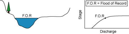
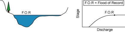
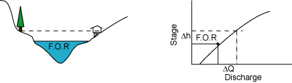
For the following figures and discussion, the flood of record (F.O.R.) is taken to represent the limit of the official rating curve even though this is not always the case for real rating curves. Also, the portion of the rating curves shown above the flood of record represents what the stage-discharge relationship would be if it were known. Finally, the rating curves are highly simplified and unrealistic scales are used to illustrate the points. The flattening of the curves shown in the example cases would actually show up on a real rating curve as a mild slope change, and may actually be concave upwards instead of as shown.
 |
| Figure 10.2. River cross section and rating curve with F.O.R. well within main river channel. |
The behavior of a stage-discharge relationship beyond the official rating curve can be roughly assessed based on the characteristics of the channel cross section at the stream gage. For example, in Figure 10.2, the cross section presents a somewhat consistent relationship between the increase in cross sectional flow area and the increase in stage. Since flow is a function of cross sectional flow area, the stage-flow (or discharge) relationship should be consistent for this cross section. Consequently, the nature of the official rating curve is a reasonable approximation of what the stage-discharge relationship should be for flows larger than the limit of the official rating curve. In this situation, extrapolation of the rating curve should produce reasonable estimate of stage.
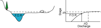
In contrast, Figure 10.3 shows a case where the cross section widens significantly into an expansive flood plain just above the flood of record (and therefore the limit of the rating curve). The nature of the stage-discharge relationship below the flood plain is therefore not indicative of what the stage-discharge relationship is above the flood plain. This is because flow that spills into the flood plain area will result in less increase in stage because of the increase in the horizontal dimension of the flow area.
 |
| Figure 10.3. River cross section and rating curve with F.O.R. at a breakpoint in the river cross section. |
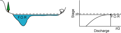
If the upper limit of the rating curve defines flows that do not quite reach the flood plain, as is the case in Figure 10.3, then extrapolating the rating curve would result in a significant over-estimation of stage for a given flow. This occurs for all flows beyond the limit of the rating curve. In Figure 10.4, on the other hand, the stage-discharge relationship is defined for flows that do spill into the flood plain. The rating curve illustrates this behavior; the flood of record is noted beyond the point where the curve becomes flatter. In this case, the trend of the upper portion of the official rating curve does present a fairly good estimate of what should be expected for flows above those defined by the official rating curve.
 |
| Figure 10.4. River cross section and rating curve with F.O.R. within the river flood plain. |
The above discussion, and Figures 10.2 through 10.4, are not intended to be the basis for quantifying the stage-discharge relationship beyond an official rating curve. The goal is to provide a conceptual understanding of the underlying principles. These principles are useful in cases were no quantifiable means exists for estimating a stage-discharge relationship for flows that are outside the limit of official rating curves. In this case, an understanding of the principles can facilitate qualitative assessments such as whether extrapolation (1) is appropriate or not, and (2) will provide an overestimate or underestimate of stage for a given flow.
Background field work is needed before the ideas presented here can be applied in an operational setting. At a minimum, WFO hydrologists can make notes based on visual inspection of forecast points in their area of responsibility, possibly with the aid of a hand held level. A typical, minimum, site inspection would involve making a simple sketch of the cross section characteristics with rough dimensions. On this sketch should be the water level associated with the limit of the official rating curve, and any critical characteristics of the channel such as large terraces and flood plain areas. The idea is to capture the characteristics of the overall channel above the rating curve, such as whether it widens to an expansive flood plain, or is it constrained between steep canyon walls.
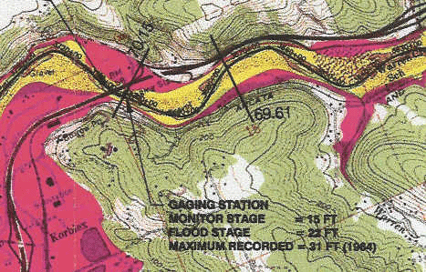
Additional information for making the sketch is available from the gage description and official rating, USGS quad maps, and E-19 reports. The cross section covered by the official rating can be obtained from the agency that maintains the rating, such as the USGS. This can serve as a starting point to which the rough estimates of dimensions can be added to describe the channel well above the rating. The hand level can be used to determine where the stage associated with the upper limit of the rating curve intersects the channel cross section. This requires the existence of high water marks or staff gages that capture the upper limit of the rating curve. Bridge pier markings are also ideal for this purpose if it is possible to get the hand level high enough to sight the markings. An example sketch is provided for the Mad River near Arcata, CA, in Figure 10.8.
The cross section sketches should be provided to the supporting River Forecast Center (RFC). During very high flow events that exceed the official rating, these sketches can provide insight into the behavior of the stage-discharge relationship that they may otherwise not have.
Information from Flood Inundation Studies
There are good sources of readily available flood inundation information for many forecast points. Two examples are Federal Emergency Management Agency Flood Studies and Dam Break Studies. Figure 10.5 shows an example of a flood inundation map for a dam break analysis for the Mad River near Arcata, CA. The area that would be inundated if the dam failure occurs during a sunny day event is shaded yellow and the red area indicates the inundation that would occur if a dam breach occurs during the flood of record event. These inundation maps were calculated using steady state hydraulic models calibrated with surveyed cross section data and estimated roughness coefficient (see Lesson 2). These same methods are also used to specifically extend a rating curve. Steady state modeling was used at this point because it was far from the dam being analyzed. While there are significant uncertainties with these methods, they do provide valuable insight into the relationship between stage and flow for very large flows. Both of these inundations far exceed the limit of the official rating curve.
 |
| Figure 10.5. Flood inundation map for a dam break analysis on the Mad River near Arcata, CA. |
The information provided in dam break studies includes the flow and stage associated with the scenarios considered. These data pairs provide, at a minimum, insight into whether a logarithmic extrapolation of the official rating curve is appropriate or not.
Figure 10.6 shows the official rating curve for the Mad River near Arcata, CA, with a logarithmic extrapolation. The triangles represent the data pairs from the dam break analysis. In this case, the log extrapolation of the rating curve underestimates the stage for a given flow in the very high flow range, when compared to the dam break analysis results. Though the scale of the curve masks the significance, the difference for the highest flow is 10 feet for an event that would register at about 50 feet of stage, a 20% difference.
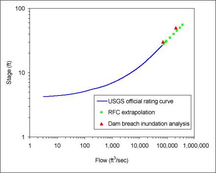 |
| Figure 10.6. Rating curve for the Mad River near Arcata, CA. |
The methods outlined in the previous section support the conclusion drawn above using dam break analysis results. Figure 10.5 shows that the Mad River channel cross section is severely constrained at a width of about 1800 feet. The closely spaced contour lines beyond that width suggest a rapid increase in elevation over little horizontal distance, for both sides of the channel. Once that point is reached, incremental increases in flow will cause a higher incremental increase in stage than if the flood plain continued to expand.
It is not suggested that the extended rating curve be abandoned in favor of the dam break results. Rather the dam break results can be used as an additional source of information for a scenario that is inherently very uncertain. In this case, the products that are issued by the NWS and the wording of those products, including their explicit and implied uncertainty, could be legitimately affected by the information provided by the dam break results.
The Salinas River near Spreckels, CA, provides another example of usefulness of dam break analysis results. In this case, shown in Figure 10.7, the data point from the dam break analysis lies beneath the extrapolated official rating curve. Again, the scale masks the significance of the difference; the dam break analysis results predict a stage that is 8 feet lower than that predicted by the extrapolated official rating curve. This is consistent with what is assessed from looking at the topography at stages above those defined by the official rating curve. The flood plain is about four miles wide at this site. Therefore, the true stage-discharge relationship for this site should be expected to indicate that increments of increased flow produce very little increases in stage, as suggested by the dam break analysis results.
 |
| Figure 10.7. Rating curve for the Salinas River near Spreckels, CA. |
Caution should be exercised when using dam break analysis results. There are several potential reasons why the results may not apply to normal river flooding conditions. If the location of interest is close to the dam that is being evaluated, for example, the hydraulic analysis will likely employ unsteady state methods to characterize the rapidly rising hydrograph. Histeresis, as discussed in lesson 8, can play a major role in this case and render the results invalid for use in evaluating the gradually rising hydrograph associated with normal river flooding.
Background work must be performed to benefit operationally from the concepts outlined above. FEMA studies and dam safety studies should be examined for valuable stage-discharge information as well as inundation maps. This information should be scrutinized for applicability to normal river flooding and evaluated for its usefulness in augmenting official rating curves. If the information is deemed valuable, it should be plotted along with the official and extended rating curve as shown in Figures 10.6 and 10.7 and made available to both WFO and RFC operational staff. Annotations can also be added to these plots to note the highest direct and indirect measurement, and incompletely defined shifts, as discussed in the previous sections.
An example of the type of information that should be documented and maintained in both WFO and RFC operational manuals is provided in Figure 10.8. It summarizes the ideas presented in several previous sections where reference is made to information that should be gathered by operational hydrologists during background work.
 |
| Figure 10.8. Rating curve and channel cross section information used for operational forecasts on the Mad River near Arcata, CA. |
Implications for issuing river forecast products
In the previous section, it was suggested that additional knowledge about the behavior of a stage-discharge relationship is useful for deciding on the wording of river products issued for floods that exceed the official rating curve. This section expands on this idea by considering the perspective of the recipient of those products.
The flood of record for a region is, by definition, the largest flood that anyone remembers. It frequently carries with it two misconceptions. First, the occurrence was a freak of nature. Secondly, the flood event can never be exceeded. For these reasons, if a region did not experience any significant property damage when the flood of occurred, the residents can feel a false sense of invincibility. The fact that a particular area was not adversely impacted by the flood of record is often cited as proof that the area is immune from flooding. These perceptions exist even when the flood of record is, statistically, not that rare or large.
 |
| Figure 10.9. Rating curve for the stream with the F.O.R. within the confined stream cross section. |
The principles discussed in the previous section can be used by WFO hydrologists to identify areas that have not been flooded previously that would likely be impacted by floods that are only moderately higher than the flood of record. Figure 10.9 shows a structure that was not affected by the flood of record. For a cross section that remains constrained above the flood of record, a relatively small amount of additional flow above the flood of record can cause flooding to the area in question. Also, the flooding that would occur in this type of cross section can easily reach well beyond the flood of record and involve high velocity flow.
Figure 10.10 shows a different scenario whereby the area at risk is on the far side of a large terrace or flood plain that was not flooded by the flood of record. In this case, the at-risk population can falsely feel safe from flooding because of their significant horizontal distance from the high water level associated with the flood of record. Floods that exceed the flood of record and reach into the terrace or flood plain and inundate areas far removed, horizontally, from the high water level associated with the flood of record. The depth and velocity of flooding in a flood plain or large terrace is fortunately normally less than in a confined channel.
 |
| Figure 10.10. Rating curve for the stream with the F.O.R. just below the level of stage of a large flood plain. |
Products issued for flooding that exceeds the flood of record should address the attitude of at-risk populations that may feel the false sense of security describe above. The selection of wording in calls to action should convey that the flooding is going to exceed the previous flood of record and should, if possible, specify areas that are at risk that have never been flooded before. Pre-flood work is required to identify such areas and provide documentation in operational manuals. This work essentially amounts to an extension of the stage-impact relationship described by the E-19 data for documented flooding impacts.
Finally, in Figure 10.11, the structure is perched well above a wide flood plain. A structure in this situation is relatively safe from events above the flood of record because the flood plain requires significant increases in flow for only moderate increases in stage.
 |
| Figure 10.11. Rating curve for the stream with the F.O.R. within the level of stage of a large flood plain. |
Lesson 10 Summary
The preceding lessons provide a background in the fundamentals of rating curve concepts and several ancillary topics. A portion of the material in the previous 9 lessons provides background knowledge that can assist hydrologists in making operational as well as developmental decisions. Portions of the material also directly relates to daily NWS hydrologist operational activities. This lesson has revisited some of the important topics from the previous lessons and summarize how they are relevant to operational river forecasting. The lesson also addressed the situation when flood levels exceed the limits of official rating curves. The material discussed here was chosen to serve as an example for how the material presented in the other 9 lessons can be either directly or indirectly integrated into operational procedures.
The following terms and concepts were introduced in this lesson and should be mastered prior to considering that the 10 lessons have been completed. Selecting a link in the list below will result in a jump to the portion of the lesson material above that covered the relevant material so that it can be reviewed as necessary.
- Definitions
- Concepts
- effects of gage location on operational forecasts
- interpreting rating tables
- impact of data availability on rating table uncertainty
- bracket extrapolation trends based on channel cross section characteristics
- extending rating table using flood inundation studies
- implications of rating table uncertainty on issuing river forecast products